Sketch
Learn how to interpret sketches, describe routes, use cardinal points, and apply geometric concepts to real-world navigation.
1 What is a Sketch? Maps vs. Sketches
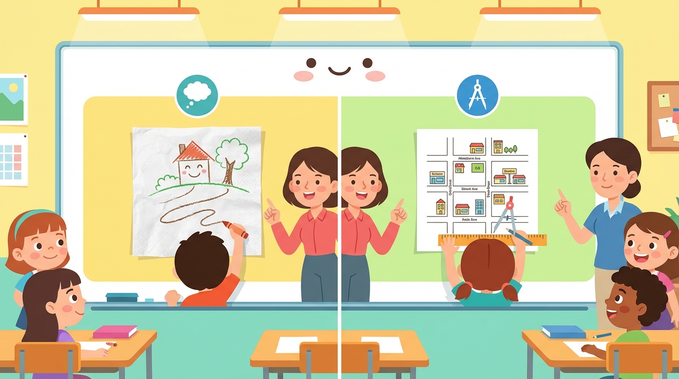
🎨 What is a Sketch?
Have you ever drawn a quick picture on a napkin to show a friend how to get to your house? That is a sketch!
A sketch is a drawing made without precise measurements or a scale. It relies on your memory or visual observation to represent a place. In mathematics, we use sketches to understand spatial relationships—like knowing what is to the left, right, or parallel to something else.
🗺️ Maps vs. Sketches: The Showdown
| Feature | Sketch (Croquis) ✏️ | Map (Mapa) 🧭 |
|---|---|---|
| Precision | Rough estimation | Exact and precise |
| Scale | No scale (sizes may vary) | Strict scale (e.g., 1cm = 1km) |
| Tools Needed | Just a pencil and paper | Satellite data, rulers, compass |
| Best For... | Quick directions to a party | Traveling across a country |
🤔 Think About It...
If you wanted to tell a new student where the cafeteria is from your classroom, would you draw a map with latitude and longitude, or a quick sketch showing the hallways?
Key Facts
2 Symbols and Legends: Decoding the Key
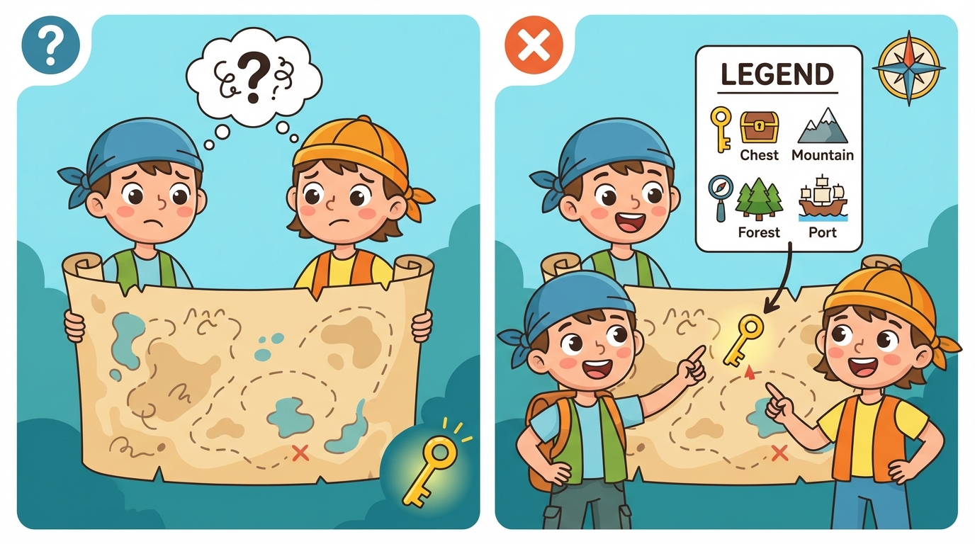
Imagine finding a treasure map, but instead of clear drawings, there are just weird shapes and lines. How would you find the gold? 🏴☠️ That represents a sketch without a Legend!
A legend (or key) is a small box on a sketch that acts like a dictionary. It tells you exactly what every symbol, line, and color represents in the drawing. Without it, a blue line could be a river... or a long snake! 🐍
Drawing every single leaf on a tree takes too long. Instead, mathematicians and cartographers use symbols—simple pictures or shapes—to represent real objects. This makes the sketch clean and easy to read.
Common Symbols in Math Sketches
| Symbol Shape | Meaning | Real Life Example |
|---|---|---|
| 🟩 (Green Square) | Park or Field | The soccer field at school |
| 〰️ (Blue Wavy Line) | River or Creek | The stream behind your house |
| ⚫ (Black Dot) | Specific Location | A bus stop or a statue |
| ══ (Double Line) | Road or Highway | Main Street |
Key Facts
3 The Compass Rose: Cardinal and Ordinal Directions
To sketch accurate maps or navigate a coordinate grid, we need to understand direction! The Compass Rose is the symbol on a map that shows us where to go. 🧭
These are the main points on the compass. In math, they form 90° right angles.
- ⬆️ North (N): 0° or 360°
- ➡️ East (E): 90°
- ⬇️ South (S): 180°
- ⬅️ West (W): 270°
Never Eat Soggy Waffles!
These directions cut the corner in half! They are exactly halfway between cardinal points, creating 45° angles.
- ↗️ Northeast (NE): Between N and E
- ↘️ Southeast (SE): Between S and E
- ↙️ Southwest (SW): Between S and W
- ↖️ Northwest (NW): Between N and W
📐 Math in Motion: Analyzing Angles
When you turn from North to East, you turn 90° (a right angle). But if you only turn from North to North-East, you are turning 45° (an acute angle). A full circle around the compass is 360°!
| Start | Turn To | Angle Type | Degrees |
|---|---|---|---|
| North | East | Right Angle | 90° |
| North | Northeast | Acute Angle | 45° |
| North | South | Straight Angle | 180° |
Key Facts
4 Street Geometry: Parallel and Perpendicular Lines
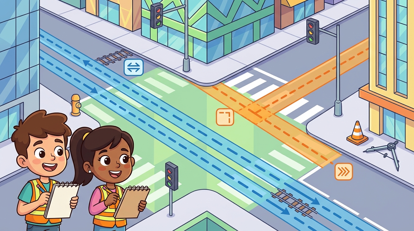
🏙️ City Planners Needed!
Have you ever looked at a city map? It looks like a giant grid! That is geometry in action. Today, we are going to learn how to sketch streets using two very special types of lines.
Imagine train tracks or the double yellow lines on a road. Parallel lines are lines that are always the same distance apart and never touch, no matter how far you extend them.
- They go in the exact same direction.
- Symbol: We use two vertical bars (||). For example: Line A || Line B.
Think of a 'T' intersection or the corner of a square building. Perpendicular lines are lines that intersect (cross) to form a perfect 90-degree right angle (like the corner of a piece of paper).
- They create square corners.
- Symbol: We use an upside-down T (⊥). For example: Line C ⊥ Line D.
Street Map Cheat Sheet 🗺️
| Type | Looks Like | Real World Example |
|---|---|---|
| Parallel | Two straight lines side-by-side (=) | Main Street and 1st Avenue running next to each other but never crossing. |
| Perpendicular | A cross (+) or corner (L) | Where a street meets an avenue at a traffic light. |
| Intersecting | An 'X' shape | Any two roads that cross, even if they don't make a perfect square corner! |
Key Facts
5 Using Grids: Alphanumeric Coordinates
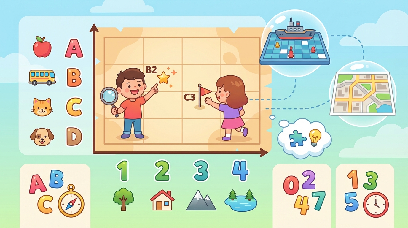
Have you ever played Battleship or looked at a city map? 🗺️ If so, you have already used alphanumeric coordinates!
An alphanumeric grid uses a combination of:
- Letters for Columns (vertical ↕️)
- Numbers for Rows (horizontal ↔️)
| A | B | C | |
|---|---|---|---|
| 3 | 🌲 | 🏠 | ☀️ |
| 2 | 🚗 | 🏫 | ⚽ |
| 1 | 🍎 | 🐕 | 🌊 |
Can you find them?
The Apple 🍎 is at A1.
The School 🏫 is at B2.
The Sun ☀️ is at C3.
Grids help us communicate exact locations quickly and clearly. Whether you are coding a game, reading a map, or designing a garden, coordinates make sure everyone is looking at the same spot!
Key Facts
6 Describing Routes: Turns, Blocks, and Landmarks
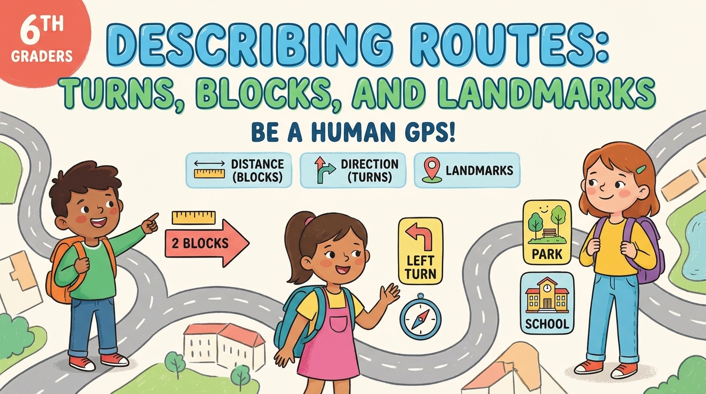
🗺️ Be a Human GPS!
When we describe a route on a sketch, we need to be precise. It is not enough to say 'go that way.' We must use three magic ingredients: Distance (Blocks), Direction (Turns), and Landmarks.
- 🧱 Blocks: In a city sketch, we measure distance in 'blocks.' One block is the distance from one street corner to the next.
- ↩️ Turns: Use precise words like 'turn left,' 'turn right,' or using cardinal points like 'head North.'
- mph Landmarks: These are prominent places (like a park, school, or statue) that confirm you are on the right path.
Imagine looking at a sketch. Here is how you describe the path:
| Step | Action |
|---|---|
| 1 | Start at the Bus Station 🚌. |
| 2 | Walk 2 blocks East. |
| 3 | Turn left at the Bakery 🥐. |
| 4 | Walk 1 block North. The Library is on your right 📚. |
Key Facts
7 Introduction to Scale: Drawing Size vs. Real Size

Have you ever looked at a map on your phone or played with a toy car? 🚗🗺️ If so, you have used Scale! Scale allows us to draw huge things (like cities) on a small piece of paper, or small things (like ants) on a big poster.
📏 What is Scale?
A scale is a ratio that compares the size of a drawing or model to the actual size of the object in real life.
When you see a scale like 1 : 100, it tells a story:
- The 1 (left) is the size on the paper.
- The 100 (right) is the size in the real world.
This means 1 unit on the drawing equals 100 units in real life!
Let's Compare: The Map vs. The Road 🛣️
Imagine we are drawing a map of your school. We can't use paper the size of the school! We have to shrink it down.
| Scale Ratio | On the Map (Drawing) | In Real Life (Reality) |
|---|---|---|
| 1 : 10 | 1 cm | 10 cm (Pencil size) |
| 1 : 100 | 1 cm | 100 cm or 1 meter (Desk size) |
| 1 : 1000 | 1 cm | 1000 cm or 10 meters (Bus size) 🚌 |
Key Facts
8 Key Vocabulary
Master these important terms for your exam:
| Term | Definition |
|---|---|
|
Sketch
Bosquejo |
A rough drawing made to show the main features of an object or scene without exact measurements.
Un dibujo rápido hecho para mostrar las características principales de un objeto o escena sin medidas exactas. |
|
2D Shape
Figura bidimensional |
A flat shape that has only two dimensions: length and width.
Una figura plana que tiene solo dos dimensiones: largo y ancho. |
|
3D Figure
Figura tridimensional |
A solid object that has three dimensions: length, width, and height.
Un objeto sólido que tiene tres dimensiones: largo, ancho y altura. |
|
Vertex
Vértice |
A point where two or more line segments or edges meet (a corner).
Un punto donde se encuentran dos o más segmentos de línea o aristas (una esquina). |
|
Edge
Arista |
The line segment where two faces of a 3D solid meet.
El segmento de línea donde se encuentran dos caras de un sólido 3D. |
|
Face
Cara |
A flat surface of a 3D solid.
Una superficie plana de un sólido 3D. |
|
Net
Desarrollo plano |
A 2D pattern that can be folded to make a 3D model.
Un patrón 2D que se puede plegar para formar un modelo 3D. |
|
Isometric Sketch
Dibujo isométrico |
A method of drawing 3D shapes on 2D paper, usually using dot paper.
Un método para dibujar figuras 3D en papel 2D, generalmente usando papel punteado. |
|
Dimension
Dimensión |
A measurable extent of some kind, such as length, width, or height.
Una medida de extensión, como el largo, el ancho o la altura. |
|
Scale
Escala |
The relationship or ratio between the size of the drawing and the actual size of the object.
La relación o proporción entre el tamaño del dibujo y el tamaño real del objeto. |
|
Label
Etiqueta |
Words or numbers added to a sketch to identify parts or show measurements.
Palabras o números añadidos a un bosquejo para identificar partes o mostrar medidas. |
|
View
Vista |
What an object looks like from a specific position (e.g., top view, side view, front view).
Cómo se ve un objeto desde una posición específica (ej. vista superior, vista lateral, vista frontal). |
|
Polygon
Polígono |
A closed 2D shape with straight sides.
Una figura 2D cerrada con lados rectos. |
|
Grid
Cuadrícula |
A network of intersecting parallel lines used to help draw shapes accurately.
Una red de líneas paralelas que se cruzan, utilizada para ayudar a dibujar figuras con precisión. |
|
Proportion
Proporción |
When the sizes of different parts of a drawing relate correctly to each other.
Cuando los tamaños de las diferentes partes de un dibujo se relacionan correctamente entre sí. |
Time to Practice!
There are 7 questions waiting for you. Questions are shuffled each attempt.
Take the Quiz